• Home
  • About
  • Listed Climbs
Menu

Jeff Hebert

  • Home
  • About
  • Listed Climbs

Northwest Face on Cashmere Mountain

May 2, 2021

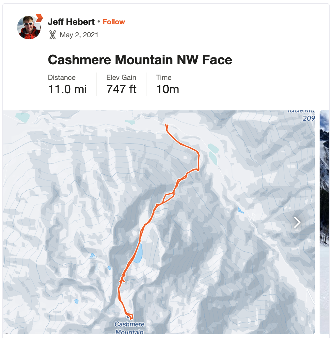
With the forecast lining up for a single day objective, Kelsey and I decided to head out to the Leavenworth area and add a new peak to our repertoire. We drove her van to the road intersection off Icicle Creek between Johnny Creek and Ida Creek around 10:30pm on Saturday night. There was enough cloud cover that it was quite dark and we couldn’t see much, but it was clear there was no snow to be found in the valley. Significant doubt set in as we conked out for the night.

We woke up at 5:45am and it was already light enough to see that there was no snow for a long ways up the mountain. The recent heat wave had significantly impacted the snowpack. We set our expectations low and donned our trail runners, planning to walk for a good ways starting at 6:30am. Thankfully, near the switchback of the forest road, a nicely-signed trail to Lake Victoria began and we followed it all the way up to near the ridge line at 3,600 feet. There were a few patches of snow to this point, but it was generally dry.

At the ridge, we couldn’t see much snow in the Victoria Creek drainage. There was a couple hundred foot section of dense slide alder that we waded through to get toward the creek, then a moderately tricky stream crossing before we got to the other side and decided to switch to skis about 2 hours from the car. We weren’t sure the snow would be continuous from here and our expectations remained low. On the more North-facing aspect, the snow was in better shape and we were able to skin up to 4,500 feet where a nice-looking gully presented itself.

We thought the summer trail followed Victoria Creek more closely, but decided this gully was more likely to have continuous snow. We skinned nearly all of it and booted the last part with icy snow. From there, we could skin again up and over a shoulder down toward Victoria Creek, eventually getting to Lake Victoria about 4 hours from the car. What a stunning spot! A bit like Colchuck Lake, but with an unfamiliar cirque of granite and no signs of civilization. Our straight-on view of the Victoria’s Secret Couloir made it look quite steep and the wet slide debris from the recent heat wave made it look like skiing it would be quite challenging.

Nevertheless, we headed across the lake to see what it looked like up close. We found the slopes to be lower angle than expected and a clear area on the climber’s right of the gully to be easy skinning. In the hot sun, we switchbacked our way up, eventually transitioning to boots and crampons to climb the gully. It got pretty steep and icy near the top, but was never too much for a single whippet.

Above the couloir, the snow was firm enough that we just stayed in boots and crampons up to a nice rest spot below the NW Face about 6 hours from the car. We had less than 1,000 feet to go at this point and could see an old boot track headed up the face. We left skis at the base of the face and headed up, traversing in from the climber’s right and then going pretty directly up to the summit block. We made it to the top in 7 hours from the car, so 1:30pm. The views of the Enchantments and Stuart Range were phenomenal. Having climbed many of the peaks and lines visible, it was really cool to see them lined up like that.

A quick downclimb closer to the North ridge brought us back to our skis. We clicked in and scraped our way down the first 500 feet or so before things warmed up and were much more fun. The couloir had seemed quite intimidating on the way up, but it wasn’t too bad to side-slip the top and then, as soon as we were through the constriction, we had the best skiing of the day on the corn below.

After a quick skate across the lake, we tried to match our up track, heading over the shoulder into our ascent drainage and then down more directly to the stream crossing. It all went smoothly and included some pretty fun turns, only getting wet and heavy down near the creek. We transitioned here 9 hours from the car and made quick work of the descent, reaching the car about 1 hour and 20 minutes later for a bit over 10 hours on the day.

Hitting this a bit earlier in the season would be recommended, but the effort to get to the snow was actually not as bad as we had expected it to be. On days when you don’t have high expectations, accomplishing anything feels pretty good. We were pretty psyched to have tagged this summit and skied this route. The subsequent burgers and beers in Leavenworth and drive home during the daylight hours added to a glorious feeling that summer is near.

In Climbing, Skiing
Comment

East Success Couloir on Mount Rainier

April 18, 2021

This route wasn’t on my radar until Adam sent a note early this spring, looking to get a group together to climb and ski the line. Reading up on the route, we’d heard of the rock bands melting out early in the season and so we looked for the first opportunity with consistent good weather to fire it up. When the recent high-pressure system gave us July in April for an entire week, it was obviously time to roll.

Adam, Colin, and I met up at Longmire at 9am on Saturday morning to register and then drove to Comet Falls, packing up and leaving the car around 10am. It was a bit tedious ascending along the summer trail with some side hilling on slushy snow, but we eventually made it to the Van Trump meadows with views of the mountain and our excitement grew. We could see ski tracks from a group that had recently been up in the Van Trump area and it looked like they’d had a great time!

The approach was pretty straightforward, heading more or less straight up before bending to the West at around 8,000 feet. 5.5 hours from the car under a hot sun and cloudless sky got us to a nice, nearly flat campsite on the East margin of the Kautz Glacier, mostly protected from ice and rock fall. That meant we were at camp by 3:30pm, enabling my most favorite thing—an afternoon nap before dinner. The sun was beating down on us in our tents, but the 9,000-foot elevation helped keep things cool enough to go down for the count after some ramen. We scouted out the Kautz crossing that evening before dinner, including a highly-awkward roped ski, then tucked ourselves in just after sunset for a 2:45am wakeup.

I slept really well, having opted to bring a warmer bag than I’d tried to get away with on Rainier before and the early morning wasn’t that painful. We took a bit longer to pack up than planned and were moving around 3:45am. With skis on our backs and short-roped together with crampons, axes, and whippets, we descended and crossed the Kautz, then ascended the Kautz Cleaver’s 50-degree snow slopes to 10,150 feet where we were able to easily traverse into the East Success Couloir. The angle eased slightly here and we swung our rope team around, getting up to 11,.000 feet before our next break at 6:15am.

The snow was odd. Small sun cups and penitentes had formed with a light coating of pumice dust everywhere. Every so often, there would be an old wind layer that was more pristine, but harder packed. We hoped it would all soften up later under another cloudless sky. We took another break at 12,000 feet, roughly an hour later. At 12,600 feet, we encountered a steep step that was mostly exposed rock. It took a bit of finesse to work through the sugar snow here. Above this, we started traversing rightwards onto more and more exposed terrain.

At 13,300 feet or so, we encountered what normally must be a rock band. For us, it was a much steeper step of snow, easily 60+ degrees. The snow up here was warming fast at this point, with a more Eastern aspect. As Adam gingerly kicked in steps and Colin and I plunged our axes to be ready for a worst-case tumble, we had a group chat. The terrain below us was steep enough and exposed enough that an unmitigated fall would not end well. None of us expected to ski down this section, so it would require booting to the top and back, easily taking 1.5-2 hours. If the snow started to wet slide, that would also be a problem. So we called it, having all been on top before and being more interested in skiing the couloir than pushing our luck.

We down-climbed to a ridge at 13,125 feet, took a break, and clicked into our skis at 11:15am. The first turn was a doozy with firm snow, steep terrain, and a lot of exposure. We scraped our way back to the rock step at 12,600 feet, popped our skis off to down climb, and then clicked back in just below. The snow had softened a bit, but was not great. All of the sun cups, wind features, and mini penitentes made for choppy skiing requiring a lot of attention. We slowly made our way down the couloir, searching for anywhere the smoother old wind layer bridged sections together.

Finally, near the bottom of couloir, we got delicious corn. The objective hazard was mostly behind us and we could go for it as much as our quads would allow. At 8,900 feet, we decided to traverse to the Kautz Cleaver to see if we could get across here. Boy were we glad we looked! The Kautz Glacier below us had a dirty, nasty icefall that we’d have to climb through if we went farther down. We were able to traverse from here, then skin back up to camp by 2pm. We packed up quickly, knowing the lower slopes. would be getting wet.

Skiing from camp to 6,500 feet or so was lovely corn which we enjoyed as much as we could in spite of our overnight packs. Below this elevation, we encountered isothermal slop. With matchstick skis and an overnight pack, I struggled my way down, reaching the car at about 4pm.

We made a good decision to turn around when we did. I can see how the couloir can be a phenomenal ski line. Unfortunately the conditions for us didn’t live up to the promise, but we did it and came out unscathed. Not sure I’ll be back on this route. I like a bit more technical (and protectable) terrain punctuated by some amount of moderate terrain. In this case, it was a consistent, long day of ~45-degree snow slopes—a bit of a slog while staying on edge the whole time.

In Climbing, Skiing
Comment

Rock-Howard-Mastiff Traverse

March 27, 2021

After a great tour on Ruby Mountain two weeks prior and with a decent forecast for a day trip Saturday, Adam gave me a call, asking if I wanted to do the Rock-Howard-Mastiff traverse. This one had been on my list for a while, especially since I’d slogged up to Rock Mountain twice before on skis only to encounter whiteout conditions and turn around before the summit. Colin was interested as well, so we joined forces, targeting a meetup at 6am in the Stevens Pass parking lot to arrange the car shuttle and get rolling at a reasonable hour.

We started skinning up for Rock at 7am, finding the low elevation terrain to be pretty patchy, especially anything with Western exposure. We switched back and forth quite a bit between skinning and booting and the snow varied from isothermal slush to refrozen crust. We eventually put ski crampons on to finish the steeper part of the ridge. All of these shenanigans lowered morale a bit, but once we gained the easier ridge, could see Rock above us, and had warm sunshine hit us, we knew it would be a good day.

There was more new snow than we expected in the alpine, but our tests show it was right-side up and well bonded to the snow below except for a few places where there was a more pronounced solar crust. We skinned most of the way up to the southern false summit of Rock before switching to boots for the final hundred feet or so. The summit had been in and out of the clouds during our ascent and we oscillated between full whiteout and gorgeous views as we traversed the ridge to the true summit. We made it here in 4.5 hours, which was right on the guidebook time and felt pretty good given the conditions.

Adam was excited about the steep North couloir, meanwhile my 2 days on alpine skis all winter had me looking for an easier start to the day. Colin and I headed down the West face for a few hundred feet before cutting right over the ridge and down below Adam so we could keep eyes on him. This was the best skiing of the day and it was awesome. A slightly rimey crust easily broke and exposed light, fluffy goodness on the West face, then the North side was foot-deep powder. We could hear Adam whooping the whole way down.

Our traverse to the NE shoulder of Rock went smoothly, staying a bit higher than the guidebook’s beta and arriving a little shy of 5.5 hours from the car. The East face down to Crescent Lake was great for a hundred feet and then turned much heavier, with lots of wet slide debris. We enjoyed a snack at the lake, looking back up at our turns, before putting our heads down for the climb up Howard. We stayed climber’s right for this ascent, sticking in the trees, given how warm it was on the South-facing slope. The climb took about 1 hour and 20 minutes, bringing us to the top of our second peak in a little under 7.5 hours from the car.

We (I) errantly went too far down Howard looking for a break in the cornice and had to boot back up a little ways to find it by the very first thumb-shaped rock, much closer to the top than expected. The ski down Howard’s East face was pretty low angle and the conditions were fun with just enough solar effect to make it faster and buttery lower down. We opted for a sweeping traverse above Canaan Lake since the skiing wasn’t worth losing more vert for. Another quick snack at the bottom and we were on the move up to Mastiff.

From Howard, Mastiff doesn’t look like a mountain so much as a glorified hill. That said, the SW face was steep enough that the sun-softened snow was slick and skinning was tricky. We stuck to the small trees on the climber’s right for the same reason as on our climb up Howard. This climb went quickly in a half hour, putting us on the summit 8.75 hours from the car. We found a nice exit from the North end of the summit and did another long, sweeping descent, this time into the gully exiting at Lost Lake.

We hit lighter snow that stuck to our skins on the climb up from Lost Lake. By the end of that climb we were all excited to be heading down. We were at 9h 45m at the point where we ripped skins and headed through the trees. To Merritt Lake was pretty easy. We pushed ourselves across and started going down very low-angle terrain from here. It was tough to stay far-enough right and we found ourselves drifting away from the summer trail. We eventually decided we needed to boot up the ridge to descend from the right spot, which was a bit painful, but short lived.

The ski out from here was pretty heinous. Recent winds had caused tree branches and needles to fall everywhere and the snow coverage was high enough to want to ski vs. walk, but low enough that slide alder was poking through everywhere. The snow was also classic, low-elevation spring concrete. We survival skied our way down, eventually hitting the forest road, which went up and was flat enough that we got quite a final arm and ab workout, not wanting to transition one more time. The descent took much longer than we’d hoped, but we still made it to the car in under 12 hours.

I’m glad I did the tour and the sections in the alpine were both gorgeous and fun. That said, I won’t feel the need to come back—the approach and descent had me yearning for ski tours with a much higher percentage of the terrain above tree line.

In Skiing, Climbing
Comment
← Newer Posts Older Posts →

Recent Trip Reports

Featured
IMG_9162.jpg
May 31, 2025
Mallory-Porter on Aiguille du Midi
May 31, 2025
May 31, 2025
ventoux.jpg
May 18, 2025
Mont Ventoux
May 18, 2025
May 18, 2025
IMG_6830.jpeg
Sep 21, 2024
South Face on Aiguille du Moine
Sep 21, 2024
Sep 21, 2024
IMG_6771.jpeg
Sep 19, 2024
Barbaresco to Barolo
Sep 19, 2024
Sep 19, 2024
IMG_3321.jpeg
Sep 15, 2024
Cosmiques Arete on Aiguille du Midi
Sep 15, 2024
Sep 15, 2024
IMG_5955.jpeg
Jul 27, 2024
Rainier Vertfest
Jul 27, 2024
Jul 27, 2024
IMG_5609.jpeg
Jul 13, 2024
Mary Green Glacier on Bonanza Peak
Jul 13, 2024
Jul 13, 2024
IMG_4891.jpeg
Apr 13, 2024
Chair Peak Circumnav CCW
Apr 13, 2024
Apr 13, 2024
IMG_8600.jpeg
Dec 14, 2023
Mount Aspiring NW Ridge
Dec 14, 2023
Dec 14, 2023
IMG_2329.jpeg
Jul 16, 2023
West Ridge on Mount Thomson
Jul 16, 2023
Jul 16, 2023
IMG_1974.jpeg
May 28, 2023
South Ridge on Mount Jefferson
May 28, 2023
May 28, 2023
IMG_1736.jpeg
May 13, 2023
Little Tahoma via Paradise
May 13, 2023
May 13, 2023
IMG_3023.jpeg
Mar 18, 2023
Nisqually Chute on Mount Rainier
Mar 18, 2023
Mar 18, 2023
IMG_9312.jpeg
Feb 12, 2023
The Slot Couloir on Snoqualmie Mountain
Feb 12, 2023
Feb 12, 2023
IMG_0141.jpeg
Sep 25, 2022
The Triad
Sep 25, 2022
Sep 25, 2022
IMG_0024.jpeg
Sep 5, 2022
Mount Fernow
Sep 5, 2022
Sep 5, 2022
IMG_9826.jpeg
Aug 7, 2022
Frostbite Ridge on Glacier Peak
Aug 7, 2022
Aug 7, 2022
IMG_9661.jpeg
Jul 23, 2022
North Face of Mount Maude
Jul 23, 2022
Jul 23, 2022
IMG_9557.jpeg
Jul 9, 2022
Tahoma Glacier on Mount Rainier
Jul 9, 2022
Jul 9, 2022
IMG_9431.jpeg
Jun 25, 2022
Squak Glacier on Mount Baker
Jun 25, 2022
Jun 25, 2022
IMG_8289.jpeg
Mar 16, 2022
Bow-Yoho Traverse
Mar 16, 2022
Mar 16, 2022
IMG_7941.jpeg
Jan 29, 2022
Oyster Couloir on Wright Mountain
Jan 29, 2022
Jan 29, 2022
IMG_7717.jpeg
Oct 16, 2021
Mount Saint Helens Windy Ridge Ride
Oct 16, 2021
Oct 16, 2021
IMG_7676.jpeg
Oct 2, 2021
North Cascades Highway Ride - Newhalem to Mazama and Back
Oct 2, 2021
Oct 2, 2021
PXL_20210721_200419965.jpg
Jul 21, 2021
Twin Sisters Traverse
Jul 21, 2021
Jul 21, 2021
IMG_7050.jpg
Jul 18, 2021
Mount Challenger via Whatcom Pass
Jul 18, 2021
Jul 18, 2021
IMG_6821.jpg
Jun 26, 2021
Emmons Glacier on Rainier Car to Car
Jun 26, 2021
Jun 26, 2021
IMG_6572.jpg
May 30, 2021
Park Glacier on Mount Baker
May 30, 2021
May 30, 2021
IMG_6402.jpg
May 15, 2021
Mesachie Glacier
May 15, 2021
May 15, 2021
IMG_6185.jpg
May 2, 2021
Northwest Face on Cashmere Mountain
May 2, 2021
May 2, 2021

© 2020 Jeffrey J. Hebert