• Home
  • About
  • Listed Climbs
Menu

Jeff Hebert

  • Home
  • About
  • Listed Climbs

Ruth Mountain

January 12, 2019

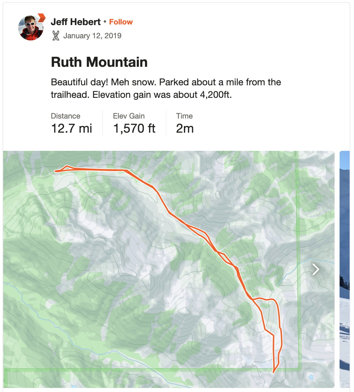
With a promising weekend forecast and a substantially-lower avalanche forecast than much of the winter so far, Kelsey and I hatched a plan to ski Ruth Mountain on Saturday as a day trip from Seattle. We knew the ski conditions wouldn’t be great, but the views would make up for it. We left town early and were able to drive most of the forest road, parking a little over a mile from the trailhead where the snow got too deep and a tree blocked the road. Another car of 3 guys had just parked before we rolled up and we ended up spending most of our day together.

We left the car at 8:30am. About 25 minutes of skinning got us to the trailhead and then we followed the summer trail since coverage wasn’t great in the valley. Lots of old avalanche debris in the gulleys and frozen snow made the long side-hill approach a bit painstaking. It took about 2.5 hours to get to the clearing below Hannegan Pass. As we climbed, the snow finally turned from a hard icy crust to lighter, fluffier happiness.

We took the shorter approach on the South side of point 5930 and started getting awesome views of Baker and Shuksan as well as The Pickets as we gained Ruth’s North Ridge. The snow became harder and the winds increased as we neared the top. We took in the views from the summit about 5.5 hours after starting our day. Being about 2pm, we didn’t linger long up top and quickly clicked into the skis to head down the north face.

With some wind loading, we took a conservative line toward the East and finished up down the face on some fun spines to stay out of the wind loaded gulleys. We traversed the terrain lower down and slid our way across the still frozen snow in the valley, eventually putting the skins back on to get up to the summer trail and keeping them on for the rolling, frozen terrain from there on out. We got to the car right about 9 hours after starting, just before a headlamp was necessary.

Fun day. A bit more horizontal and rolling travel than I was expecting. The views were stellar and the skiing up high was better than expected.

In Skiing
Comment

Table Mountain Circumnavigation

April 22, 2018

Kelsey and I originally planned to ski Ruth Mountain this weekend to soak in views without worrying too much about avalanche potential after recent spring storms and warming temperatures.  We drove up to the Hannegan Pass Road on Saturday night, planning to drive up to the trailhead, but quickly encountering more snow on the road than we could drive through.  We called it a night there and gave it a brief shot early in the morning, but quickly discovered that the road was melted out further up, which would have meant walking over 6 extra miles each way, so we bailed and drove up to the Baker ski area instead, took a nap, and then headed off for a tour around Table Mountain.

We left the car just shy of 9am under clear skies with awesome views around the range.  We made it to Artist Point in about 35 minutes, ripped skins and did a long traverse below Table's South face, and climbed up to the base of Ptarmigan Ridge in about 70 minutes from the car.  The ski down to Mazama Lake was pretty fun, though short lived.  We skinned back up here and cruised across Iceberg Lake and up the steeper section to the saddle between Table and Mazama Dome about 1 hour and 50 minutes in.

The first 500 feet or so was pretty fun skiing on easy terrain before finishing the ski on increasingly heavy, wet snow and traversing, then skinning out to the car, finishing in 2.5 hours.  Beautiful day and great views with better-than-expected snow.  I just wish we'd gotten on top of something a bit more ambitious! 

In Skiing
Comment

Scraping my way down at the edge of the basin

The Brothers East Basin

April 1, 2018

From my apartment in Seattle, The Brothers are a prominent landmark on the Westerly horizon.  During clear days in the winter and spring, the snowy East Basin looks like an alpine playground, so I just had to check it out.

Kelsey and I drove over on Saturday night after dinner, arriving at the Lena Lake Trailhead at about 10pm with enough time to enjoy a beer before going to sleep in the back of the car.  We woke up at 4am and were on the trail with skis on our backs by 4:45am.  It was an hour on the dot to the sign at the South end of Lena Lake.  We made a bit of a wrong turn here in the dark, thinking we needed to stay right along the lake and realized our error after hitting a pretty bushwhacky section right next to the lake.  We doubled back and regained the normal trail, only losing 15 minutes or so, which took us exactly where we wanted to go—past the Lena Lake campground and to the Northwest corner of the lake, where we crossed the river and headed up the Valley of Silent Men.

At the head of The Valley of Silent Men

We started encountering ice and snow on the trail, but it wasn't consistent enough to start skinning, so we plodded along, sometimes in foot-deep snow, until we were in the lower-angle area at about 3,100 ft and 3 hours in or so.  It started snowing very lightly at this point, but was calm.  We skinned up, past a campsite, and to the head of the valley where the route finding began about 4.5 hours in at 3,600 ft.  While it looked tricky, with a series of cliffs and tighter trees, it wasn't actually that bad.  The snow was an unfortunate breakable crust, which was pretty slick, but could be packed just slightly, so we took turns bashing our way up.  A couple of sections were too steep and tight to skin, so we booted those brief bits, breaking fully through the crust and post holing up to our knees.  A few curses were uttered for sure.

Route finding through the cliffbands

Halfway through this section, the weather started to get worse—visibility reduced and the snow started falling harder.  While it wasn't pleasant, it also didn't feel unsafe, so we kept going, hoping that things would clear up for us.  We eventually made it to the top of the steep section and entered the basin at about 5,000 ft 6 hours in.  It was a total milk bottle up there, at times so bad that we felt vertigo not being sure if we were about to be going up or down the slopes.  Still holding out hope, we kept going up and got to the high bench at 5,800 ft about 6.5 hours in.  At this point, we were quite close to the top and couldn't see it at all, so we sat down and decided to have lunch while waiting it out.  Going up the couloir in the whiteout didn't seem wise and would only be to tag the summit—not really the goal.

At our high point

45 minutes later, the visibility hadn't improved, so we started skiing down.  About 1,500 feet lower, as we were in the middle of the cliff band section, it cleared up significantly and the sun came out.  Damn!  We decided it was hard to know if the summit was actually clear and it wasn't worth heading back up, so we kept going down, reversing our tracks, switching back to shoes at the same point where we'd left them (and the whiskey), and hiking our way back out to the car, reaching it about 11.75 hours after we'd started.

While it was a bummer to not get on top, I'd rather do it when the views are clear and I can look back at my apartment as a spec on the horizon.  It was a good training mission regardless.

It was not lost on us that we'd been fooled on April 1st.  We drowned our sorrows at the Hamma Hamma Oyster Saloon.

In Climbing, Skiing
Comment
← Newer Posts Older Posts →

Recent Trip Reports

Featured
IMG_9162.jpg
May 31, 2025
Mallory-Porter on Aiguille du Midi
May 31, 2025
May 31, 2025
ventoux.jpg
May 18, 2025
Mont Ventoux
May 18, 2025
May 18, 2025
IMG_6830.jpeg
Sep 21, 2024
South Face on Aiguille du Moine
Sep 21, 2024
Sep 21, 2024
IMG_6771.jpeg
Sep 19, 2024
Barbaresco to Barolo
Sep 19, 2024
Sep 19, 2024
IMG_3321.jpeg
Sep 15, 2024
Cosmiques Arete on Aiguille du Midi
Sep 15, 2024
Sep 15, 2024
IMG_5955.jpeg
Jul 27, 2024
Rainier Vertfest
Jul 27, 2024
Jul 27, 2024
IMG_5609.jpeg
Jul 13, 2024
Mary Green Glacier on Bonanza Peak
Jul 13, 2024
Jul 13, 2024
IMG_4891.jpeg
Apr 13, 2024
Chair Peak Circumnav CCW
Apr 13, 2024
Apr 13, 2024
IMG_8600.jpeg
Dec 14, 2023
Mount Aspiring NW Ridge
Dec 14, 2023
Dec 14, 2023
IMG_2329.jpeg
Jul 16, 2023
West Ridge on Mount Thomson
Jul 16, 2023
Jul 16, 2023
IMG_1974.jpeg
May 28, 2023
South Ridge on Mount Jefferson
May 28, 2023
May 28, 2023
IMG_1736.jpeg
May 13, 2023
Little Tahoma via Paradise
May 13, 2023
May 13, 2023
IMG_3023.jpeg
Mar 18, 2023
Nisqually Chute on Mount Rainier
Mar 18, 2023
Mar 18, 2023
IMG_9312.jpeg
Feb 12, 2023
The Slot Couloir on Snoqualmie Mountain
Feb 12, 2023
Feb 12, 2023
IMG_0141.jpeg
Sep 25, 2022
The Triad
Sep 25, 2022
Sep 25, 2022
IMG_0024.jpeg
Sep 5, 2022
Mount Fernow
Sep 5, 2022
Sep 5, 2022
IMG_9826.jpeg
Aug 7, 2022
Frostbite Ridge on Glacier Peak
Aug 7, 2022
Aug 7, 2022
IMG_9661.jpeg
Jul 23, 2022
North Face of Mount Maude
Jul 23, 2022
Jul 23, 2022
IMG_9557.jpeg
Jul 9, 2022
Tahoma Glacier on Mount Rainier
Jul 9, 2022
Jul 9, 2022
IMG_9431.jpeg
Jun 25, 2022
Squak Glacier on Mount Baker
Jun 25, 2022
Jun 25, 2022
IMG_8289.jpeg
Mar 16, 2022
Bow-Yoho Traverse
Mar 16, 2022
Mar 16, 2022
IMG_7941.jpeg
Jan 29, 2022
Oyster Couloir on Wright Mountain
Jan 29, 2022
Jan 29, 2022
IMG_7717.jpeg
Oct 16, 2021
Mount Saint Helens Windy Ridge Ride
Oct 16, 2021
Oct 16, 2021
IMG_7676.jpeg
Oct 2, 2021
North Cascades Highway Ride - Newhalem to Mazama and Back
Oct 2, 2021
Oct 2, 2021
PXL_20210721_200419965.jpg
Jul 21, 2021
Twin Sisters Traverse
Jul 21, 2021
Jul 21, 2021
IMG_7050.jpg
Jul 18, 2021
Mount Challenger via Whatcom Pass
Jul 18, 2021
Jul 18, 2021
IMG_6821.jpg
Jun 26, 2021
Emmons Glacier on Rainier Car to Car
Jun 26, 2021
Jun 26, 2021
IMG_6572.jpg
May 30, 2021
Park Glacier on Mount Baker
May 30, 2021
May 30, 2021
IMG_6402.jpg
May 15, 2021
Mesachie Glacier
May 15, 2021
May 15, 2021
IMG_6185.jpg
May 2, 2021
Northwest Face on Cashmere Mountain
May 2, 2021
May 2, 2021

© 2020 Jeffrey J. Hebert