The Pickets exemplify untamed natural beauty. With so much of the world feeling increasingly connected and trodden, this range makes it feel like you’ve traveled back in time, stripping everything away. Even the primary access trail to the more frequented Southern Pickets is overgrown and faint in many places.
My first trip into the Pickets was with Dale in August of 2016 to climb the East Ridge of Inspiration Peak. I remember the approach feeling pretty long and the climb having an especially remote feel to it. Nearly a decade later, I found myself with no work responsibilities, full-day childcare for both kids, a perfect forecast with no smoke, and a wife willing to let me get away for a big day out, so I went for it.
I decided to do it ‘home to home’ with a start from Seattle at 4am, putting me at the trailhead right around dawn to avoid needing a headlamp. I was able to go pretty light with just a running vest backpack, a bunch of food, water and a filter, some layers and basic med/essentials kit for safety, trekking poles, and a helmet plus light crampons just in case. I set off from the Upper Goodell Creek Trailhead at 6:30am.
I knew the first section of trail was pretty flat for about 4 miles and had seen from some Strava research that faster folks were doing it in a little under an hour, so I settled into a slow jog where the terrain allowed it. I made it to the turn in about 54 minutes, stopping here quickly to put down some calories. The grunt up the ridge felt surprisingly good with my legs still having quite a bit of fitness from our 3-month Europe parental leave trip in them. This main ridge section took just over 1.5 hours.
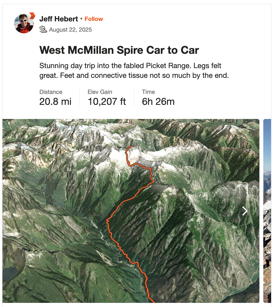
After admiring my first views of the Southern Pickets, I continued along through the heather benches and rocky traverse to the notch. There were ample blueberries along the way and I kept thinking “If I were a bear, this is where I’d want to be right now,” so I exclaimed “Hey bear!” whenever it seemed like I might startle one around a corner. The loose descent from the notch was crappy but short lived and I was sitting on a rock, filtering water at the main campsite just under 3.5 hours from the car. I knew from other trip reports that this was reasonably quick. My body still felt pretty good and seemed to be doing well with the amount of calories, carbs, electrolytes, and water I was ingesting.
The traverse and descent to the outlet of the glacial lake below McMillan Spire went pretty quickly except for one scary moment when the talus I was standing on moved quickly and unexpectedly, pitching me forward awkwardly and landing me on my left wrist. Having surgically reconstructed the right one before, I was nervous, wrapping it and taping it with the supplies I’d brought to protect it for the rest of the day.
From here, I scampered up the slabs and across a very short snowfield to get to the nasty, loose, 3rd class gully on the way to the notch at the base of McMillan’s West Ridge. After some perseverance through a few moments of infinite escalator steps in the scree, I reached the ridge where things improved significantly. I was surprised by how short the ridge itself felt once I was on it. My legs were inexplicably still feeling quite good at this point and I marched my way to the summit right at 5.5 hours from the car.
I took a few moments to savor the views and remoteness. Standing on the top totally alone was a bit of a wild feeling. Based on the one other party parked at the trailhead that morning who I had chatted up about their plans to head for the Chopping Block, it was likely that the closest human was many miles away over some of the most rugged terrain in the lower 48. Good thing I had a sat phone just in case.
There’s very little to say about the descent. The gully wasn’t as bad, the snow was fun but short-lived, the slabs went quickly, and the climb over the notch felt pretty short. I’d made it back to the campsites about 7.5 hours after starting, so the round trip to the summit from camp was 4 hours. I kept trying to stay fueled and hydrated on the way down. The ridge descent was very painful, mostly on my feet. Since it’s so steep, it was hard to avoid my toes being jammed into the fronts of my trail runners with each step, slowly accumulating quite the set of toenail bruises.
By the end of the ridge, I jogged the short ways over to the stream and sat there with my feet in the frigid water for 15 minutes or so while filtering more water to drink. This helped take the edge off a bit and enabled me to old-man shuffle the rest of the way to the trailhead. I slowed considerably on the ridge and trail back out, which resulted in a slightly longer descent than ascent and arriving back to the car 11.5 hours after I’d started. Still a pretty respectable time for such a remote, rugged objective with a lot of vertical gain (and loss)! I was back home before dark in Seattle at 8:30pm.