• Home
  • About
  • Listed Climbs
Menu

Jeff Hebert

  • Home
  • About
  • Listed Climbs

Adam on his way back across the traverse

South Ridge on Mount Jefferson

May 28, 2023

Given its distance from Seattle, Mount Jefferson had sat on my list for a while and so I was excited when I dropped a line to my friend Adam in advance of Memorial Day weekend to hear that he and his friend Eric were planning to climb its South Ridge. We left Seattle early on Saturday morning and arrived at Pamelia Lake Trailhead around 11:30am. After debating the merits of various forms of protection and gear (we went in heavy with a tent per person), we started hiking in trail runners with overnight, ski, glacier, and steep snow gear on our backs.

About a mile after reaching the PCT, we started to hit snow, but it was too patchy to make sense to switch to our boots and skins. By the time the snow was clearly continuous enough, we were nearing Shale Lake and our camp for the night and it didn’t make sense to transition. It took a little over 4 hours to make it those 8 miles from the car. We set up our luxurious array of tents and took a nap before dinner—one of my all-time mountain adventure favorite activities.


With temperatures around freezing overnight and a relatively cool day expected, we weren’t in a big rush in the morning. We were up at 5am and moving by 6am after scraping the frost off our skis. The ascent went very smoothly from camp at 5,900 feet to the point where the ridge steepened at 9,500 feet in about 3 hours. We left our skis here and switched to crampons, ascending the ridge and then steep snow just to the East of it until we reached the red saddle at about 10,250 feet roughly an hour later.

The steep snow traverse was intimidating from this vantage point, especially given a series of deep runnels cutting through it. We had a snack, got our two tools out, made sure our crampons weren’t going to skate around on us, and then I set off, offering my toes to the foothold gods. It would have been difficult to protect this section well without a lot of pickets and patience. While it was steep, the pick placements and feet were good enough that we each soloed across. The runnels were quite a 3-D challenge to get good footholds and sticks to step in and then back out, but we figured it out. It took about 45 minutes to painstakingly crab walk across this section to reach the ridge and slightly lower-angle terrain on the other side.

We continued to corkscrew around, eventually reaching a rime-covered ramp toward the summit requiring quite a bit of front pointing and high daggering. I got to a point just a few feet below the top where pulling on the final steep rime mushroom feature didn’t seem worth the risk to poke my head just over the top and so I called it good here and down-climbed. Eric and Adam had made similar decisions a bit earlier. We regrouped at the beginning of the traverse back across and were much faster on the way back with the face warming up considerably in the sun and our footsteps already being cut.

A quick romp plunge-stepping down the snow next to the ridge got us to our skis. It was about 2:30pm at this point but the snow was still in prime spring conditions and we whooped our way down the mountain, reaching our tents in about 40 minutes, savoring it and taking our time.

We decided that it would be worth beating Memorial Day traffic and not hiking out on frozen snow, so we packed up camp, skied out as much as we could, cut one switchback on snow, and then hoofed it out, aided by pain-killing whiskey in about 3.5 hours from camp to the car around 8:30pm. That made for a very late arrival home in Seattle, but it was worth having a whole holiday at home as well.

Especially in the rimed-up spring conditions we encountered, the last 1,000 feet of this route were appreciably more technical than the normal routes on other Cascade volcanoes. I was glad to have a bunch of steep snow experience before tackling this one.
See our GPS Track here

In Climbing, Skiing
Comment

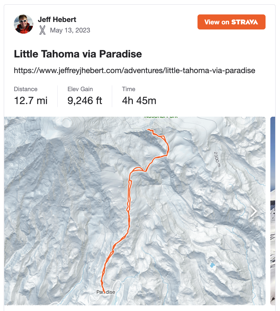
Little Tahoma via Paradise

May 13, 2023

Little Tahoma had been on my list for years but I had always prioritized other peaks and routes. With a heat wave this weekend and one day to get outside, getting high in MRNP seemed like a good plan. Colin and I decided to be responsible mountain citizens and secure a permit, which meant with work schedules that we had to wait until 7:30am when the ranger station was open. We left Seattle at 5am, secured our permit after waiting in line for a bit while all geared up at 8am, and left the Paradise parking lot just after 8am.

It was smooth sailing in the conga line up the Muir Snowfield until we curved climber’s right away from the beaten path around 8,500 feet. As we traversed onto the Cowlitz Glacier, we decided to deviate from the guidebook instructions and rise up to almost 9,000 feet to get around the crevasses and seracs. This involved a little extra effort, but was very smooth and straightforward. We then were able to slide our way down to 8,600 feet again to cross the rock rib with only a short stint on rock and dirt.

The Ingraham Glacier was even more straightforward. We did a descending traverse to 8,350 feet or so before rising back up to the Whitman Glacier access col. This face was pretty firm but we didn’t need crampons since there was an existing boot pack. We reached the col 3 hours and 15 minutes after starting our day—reasonably quick compared to the ski touring guidebook estimates, so it seemed our up and down approach across the Cowlitz and Ingraham Glaciers had paid off.

After a snack, we booted (with some terrible isothermal post holing) up the steep snow just below the rock cliffs and did a steep traverse on snow that was pretty warm and slushy but not showing signs of full-on wet slide. This brought us to the cirque below the Southeast Face of Little Tahoma at about 9,200 feet. We skinned for a ways before hooking into a nice boot pack which carried us up about 800 feet below the summit. Some trail breaking in snow from here (ski tracks must have filled in the boot pack) got us to 100 feet from the top where we scrambled up rock, across the ridge, and then down and back up to the summit.

The last 50 feet or so were heads-up in ski boots, but we never felt the need to get the rope out in either direction. We reached the summit 6 hours and 20 minutes from the car and soaked in our up-close-and-personal view of Rainier. The exposure on the Northwest Face of Little Tahoma is pretty breathtaking from the top.

Our descent from the summit to our skis was forgettable in deep isothermal slush but the ski from there made up for it, with heavy, buttered corn and a perfect slope angle to enjoy it. We retraced our steps back out and got to the car just over 9 hours after we’d started. This day ended up being a bit bigger and more effortful than expected with our extra elevation gain in both directions and the slushy snow, but was right within the time expectation we had. Great day!

In Climbing, Skiing
Comment

The Triad

September 25, 2022

The Triad had come up a few times in conversations with climbing partners over the years. Goran had suggested we climb it on our way to the West Ridge of Eldorado. Colin and I had thought about ski touring over to it from Hidden Lake Lookout. But it hadn’t quite made it to the top of the list yet. During this odd time when my rock climbing shape is at an all-time low, it seemed like a nice single-day, late-summer objective.

Mitch and I drove to the Hidden Lake Trailhead on Saturday night and found a nice flat spot to sleep for the night. We’d packed and remembered everything except for his sleeping bag, and so he spent a pretty sleepless handful of hours while I happily floated off to sleep. We got moving right around 5:15am on Sunday morning, making quick time and reaching our turnoff from the main trail in 1 hour. Less than 15 minutes later, we were at the saddle to start the ridge as the sunrise alpenglow started lighting up the North Cascades.


The heather-covered ridge was truly awesome, with views of Baker, Shuksan, and The Pickets to the Northwest and the North Cascades laid out all around us otherwise, with Eldorado, Forbidden, Boston, Sahale, and Johannesburg close by and a close-up view of Hidden Lake. We hiked along the ridge for about 30 minutes before finding the spot to descend to the glacier on the North side of the ridge. It was quite firm in the early morning and we were glad we’d brought aluminum crampons and light axes.

The 3rd class descent toward the South from the next saddle at the end of the glacier section was pretty terrible. Loose rock and dirt on top of very steep rock and heather made for a stressful hundred feet or so before it turned into just plain unpleasant scree. We were glad to get past this “Drainage of Despair” as Mitch dubbed it and into the next drainage to the East, which was much better-behaved. We found our way down and across this drainage, then headed straight for the high saddle which started the East Ridge. It was about 9:45am at this point, so roughly 4.5 hours from the car. Things had slowed down considerably since the trail had ended on the ridge.

We had a snack and put our harnesses on before heading along the ridge. It was relatively straightforward to gain the ridge via some ramps and then a slabby section that switched back near the crest where we saw an old rap anchor. The very next section was the low-5th class pinnacle, which we decided to rope up for. I plugged in a little bit of gear, but the protection wasn’t great. Thankfully, while the climbing was exposed and relatively steep, it was quite easy with good holds throughout. I belayed Mitch through this section and then we scrambled together to the true summit at 11:15am, 6 hours after leaving the car. Our up-close-and-personal view of Eldorado was pretty awesome.

There’s not much to report about our descent. We rappelled the 5th class step and scrambled through everything else. The heather-covered ridge was now showing off all of its colors. And we saw a bear sauntering along the trail ahead of us. Whiskey helped me float down from the main trail junction pretty expeditiously for a car-to-car of about 10.5 hours. While the climb itself was short lived and the Drainage of Despair was pretty terrible, it was a gorgeous place and a nice, low-5th climb in the heart of the North Cascades.

In Climbing
Comment
← Newer Posts Older Posts →
No results found

Recent Trip Reports

Featured
IMG_4795.jpeg
September 20, 2026
Mount Constance South Chute
September 20, 2026
Read more →
September 20, 2026
IMG_4236 (3).jpeg
August 6, 2026
Inspiration Traverse - Eldorado, Austera, Dorado Needle
August 6, 2026
Read more →
August 6, 2026
IMG_3486.jpeg
May 2, 2026
Boulder Glacier on Mount Baker
May 2, 2026
Read more →
May 2, 2026
IMG_1725.jpeg
August 22, 2025
West McMillan Spire Car to Car
August 22, 2025
Read more →
August 22, 2025
IMG_1244.jpeg
July 23, 2025
Via Ferrata Ferrari at Ra Bujela
July 23, 2025
Read more →
July 23, 2025
IMG_1208.jpeg
July 22, 2025
Dolomiti Vertfest
July 22, 2025
Read more →
July 22, 2025
IMG_1047.jpeg
July 19, 2025
Via Ferrata Tomaselli to Punta Fanes
July 19, 2025
Read more →
July 19, 2025
IMG_1014.jpeg
July 18, 2025
Via Ferrata Bianchi to Cristallo Mezzo
July 18, 2025
Read more →
July 18, 2025
IMG_5941.jpeg
July 15, 2025
Lake Sorapis & Via Ferrata Alfonso Vandelli
July 15, 2025
Read more →
July 15, 2025
IMG_0740 (1).jpeg
July 14, 2025
Ra Gusela and Averau Vie Ferrate
July 14, 2025
Read more →
July 14, 2025
IMG_0715.jpeg
July 11, 2025
Sci Club 18 Via Ferrata
July 11, 2025
Read more →
July 11, 2025
IMG_0634 (1).jpeg
July 10, 2025
Punta Anna and Tofana di Mezzo Via Ferrata
July 10, 2025
Read more →
July 10, 2025
IMG_0544.jpeg
July 9, 2025
Via Ferrata Michielli Strobel
July 9, 2025
Read more →
July 9, 2025
IMG_0309.jpeg
July 3, 2025
Tridentina al Pisciadù Via Ferrata
July 3, 2025
Read more →
July 3, 2025
IMG_0252.jpeg
June 30, 2025
Sellaronda
June 30, 2025
Read more →
June 30, 2025
IMG_0210.jpeg
June 28, 2025
Sass Rigais Via Ferrata
June 28, 2025
Read more →
June 28, 2025
IMG_9843.jpeg
June 19, 2025
Giro d'Langhe
June 19, 2025
Read more →
June 19, 2025
IMG_9781.jpeg
June 17, 2025
Aiguilles Marbrées Traverse
June 17, 2025
Read more →
June 17, 2025
IMG_9534.jpeg
June 9, 2025
Midi-Plan Traverse
June 9, 2025
Read more →
June 9, 2025
IMG_9162.jpg
May 31, 2025
Mallory-Porter on Aiguille du Midi
May 31, 2025
Read more →
May 31, 2025
ventoux.jpg
May 18, 2025
Mont Ventoux
May 18, 2025
Read more →
May 18, 2025
IMG_6830.jpeg
September 21, 2024
South Face on Aiguille du Moine
September 21, 2024
Read more →
September 21, 2024
IMG_6771.jpeg
September 19, 2024
Barbaresco to Barolo
September 19, 2024
Read more →
September 19, 2024
IMG_3321.jpeg
September 15, 2024
Cosmiques Arete on Aiguille du Midi
September 15, 2024
Read more →
September 15, 2024
IMG_5955.jpeg
July 27, 2024
Rainier Vertfest
July 27, 2024
Read more →
July 27, 2024
IMG_5609.jpeg
July 13, 2024
Mary Green Glacier on Bonanza Peak
July 13, 2024
Read more →
July 13, 2024
IMG_4891.jpeg
April 13, 2024
Chair Peak Circumnav CCW
April 13, 2024
Read more →
April 13, 2024
IMG_8600.jpeg
December 14, 2023
Mount Aspiring NW Ridge
December 14, 2023
Read more →
December 14, 2023
IMG_2329.jpeg
July 16, 2023
West Ridge on Mount Thomson
July 16, 2023
Read more →
July 16, 2023
IMG_1974.jpeg
May 28, 2023
South Ridge on Mount Jefferson
May 28, 2023
Read more →
May 28, 2023

© 2020 Jeffrey J. Hebert