• Home
  • About
  • Listed Climbs
Menu

Jeff Hebert

  • Home
  • About
  • Listed Climbs

Emmons Glacier on Rainier Car to Car

June 26, 2021

With an unprecedented heat wave hitting the Pacific Northwest, it seemed one place to escape the heat was up high. Temperatures were expected to reach crazy levels on Sunday and Monday, so Colin and I decided to go for a single-day ascent of the Emmons, leaving the car earlier than I ever had before—10pm on Friday night.

IMG_6815.jpg

It wasn’t quite fully dark when we started off, which started the surreal experience. Thankfully, the temperature was pleasant at that time and the moon was full, bathing the mountain in soft, white light and making the glaciers pop against a darkening night sky.

We made it to the moraine at the base of the Interglacier in about 1h and 40min and decided to take a 20-minute nap there since we were ahead of schedule. I drifted off for a few minutes after taking in the starry sky.
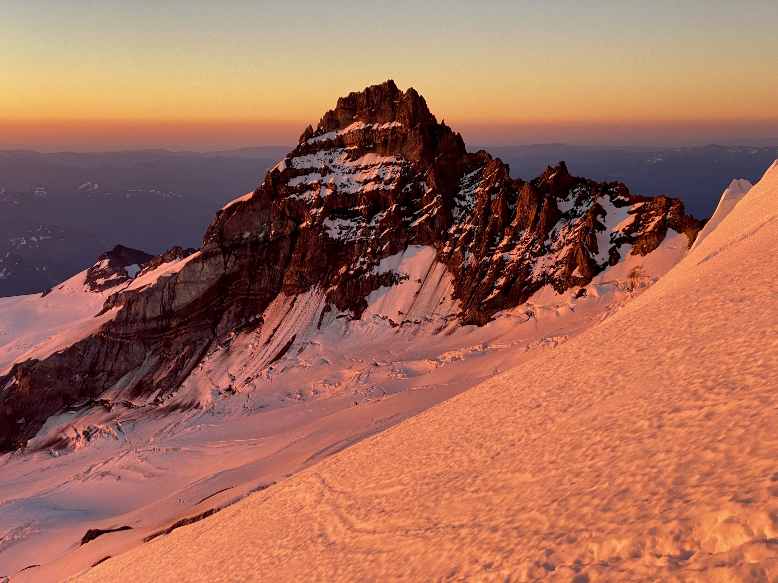
We left our trail runners on the moraine and put on our skis. The snow had firmed back up, but wasn’t icy, which led to pretty efficient skinning. From the base of the moraine, we made it to Camp Curtis in about 2h 20min. The descent down to the lower Emmons Glacier was partially dry. We roped up there and were able to easily follow the cattle path around large crevasses to Camp Schurman about 6h after we’d left the car.

We were able to skin quite a ways up the Emmons, through most of The Corridor to about 11,500 feet. The rest of our ascent was straightforward with skis on our backs, booting up at a measured (and slowing) pace. The bergschrund was open across the face, but still a small enough gap that we could reach over and make a big high step to cross the chasm. The route topped out on the crater a little ways away from the summit and we decided it was worth walking over without our packs. We arrived as the only ones at the top at 10:45am, just shy of 13 hours after we’d started. The wind was ripping as usual up there and I had a bit of a headache from the altitude, so we didn’t stay long.
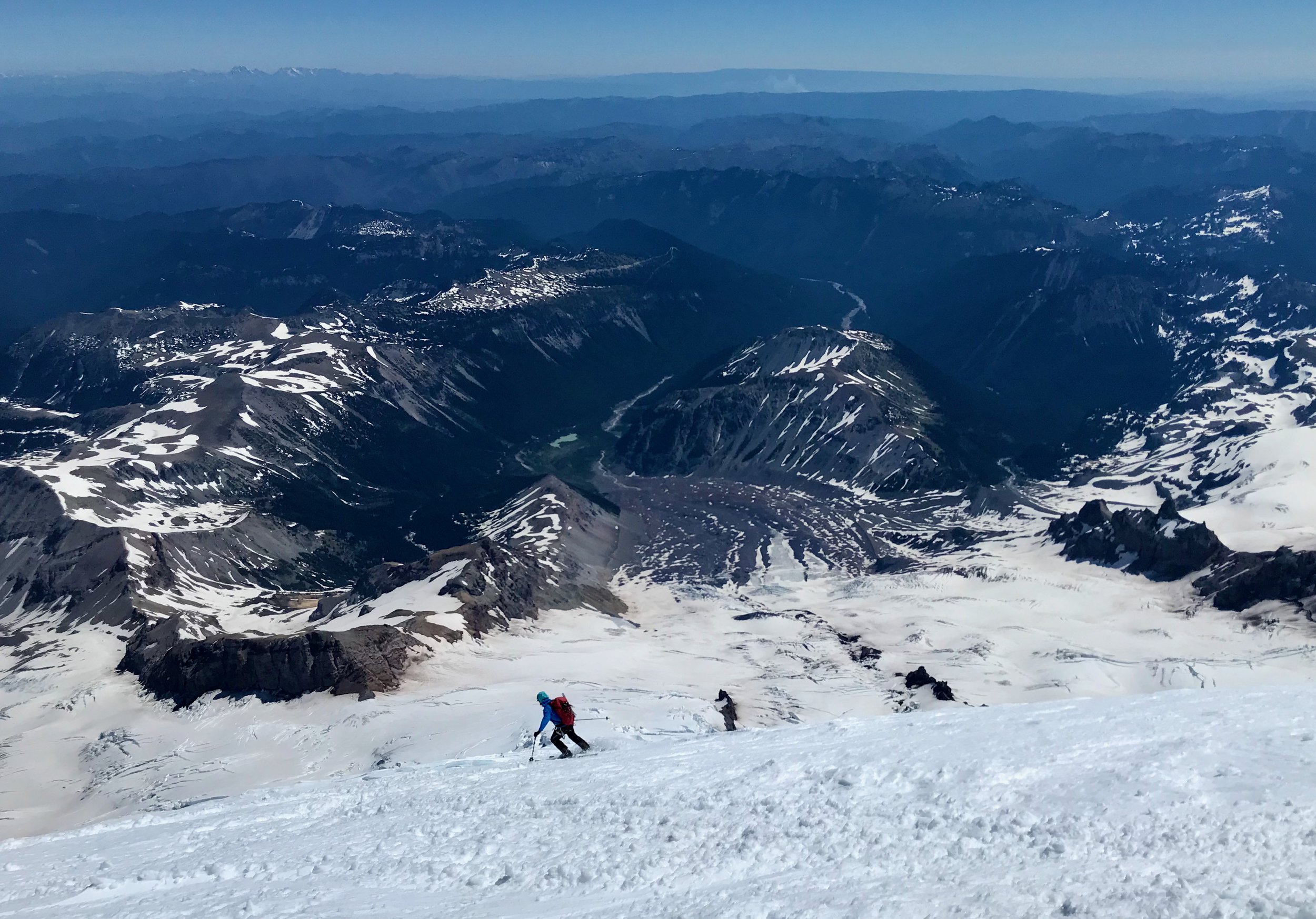
As my friend Dale says, “volcanoes are for skiing.” We clicked in on the crater rim and proceeded to enjoy somewhat-heavy corn skiing right from the top. “Hucking our meat” over the small vertical bergschrund gap was pretty fun. It only took an hour and a bit to get back to Camp Schurman. We rested a bit and chatted up the climbing rangers there before heading down the lower Emmons, booting up to Camp Curtis, and then getting our second ski run in down the Interglacier. It was nearly 1pm at the top of the Interglacier and we were nervous it would be a mashed potato mess, but it ended up being the best corn skiing of the day. We passed a number of conga lines of parties headed up as we whooped our way down.

We were able to ski all the way to our shoes at 6,100 feet and it only took 20 minutes to ski the whole thing. The hike out in short shorts was not as painful as I’d expected it to be and we made it to the car at about 3pm. The timing of the whole trip felt surreal—there was still a lot of day left. We weren’t trying to rush and our time at a little over 17 hours certainly wasn’t breaking any records, but it was fun to go fast(er) and light and experience the whole mountain in a day once again (see my Liberty Ridge Car to Car trip report here).

In Climbing, Skiing
Comment

Park Glacier on Mount Baker

May 30, 2021

With a decent forecast over the long Memorial Day Weekend, Colin and I decided to put the work in to access the remote Northeast side of Mount Baker. It turned out we timed our trip quite well, being able to skin straight from the Heather Meadows parking lot at the Mount Baker Ski Area and encountering some tricky, but doable crevasse crossings near the top of the route.

Expecting about 4-5 hours of approach, we left Seattle in the late morning, departing from the car at 1:30pm. It was hot in the bright sun as we climbed up to Artist Point and even hotter climbing up to the shoulder of Table Mountain without much of a breeze. We made it here in about 1h 20m from the car—not bad for schlepping overnight gear!

The short descent toward Ptarmigan Ridge wasn’t worth transitioning for, so we awkwardly skied down the sticky warm snow and across to a point where we could start climbing again. We decided to stay relatively high and climber’s left along Ptarmigan Ridge. While this likely included a bit of extra up and down, we were able to stay with skins on all the way to the saddle next to Coleman Pinnacle, arriving in about 3 hours from the car.

We did a curling traverse down and skier’s right from the saddle, keeping skins on again. This got us to what’s marked as Camp Kiser on some maps, which has a fabulous view of Shuksan. We decided to press on to The Portals, with one more awkward skins-on descent and one more climb before reaching our destination for the day after 4 hours on the dot (5:30pm). We dug out a campsite, set up shop, and enjoyed a lovely evening watching the mountain pink up.

Knowing the upper Northeast-facing cirque would bake as soon as the sun rose, we got going decently early, skiing away from camp at 5am. There is a cliff band at roughly 6,150 feet which is tough to scope well from above. We eventually found an exit we could ski at the far skier’s right edge of our traverse from camp, then skied down onto the Rainbow Glacier. The snow was quite firm but the angle looked reasonable to skin all the way up, so we put ski crampons on.

Our ascent of the glacier went smoothly, weaving around crevasses as we encountered them and using some photos we’d taken of the route from camp the evening prior. A big sulfur vent near 8,000 feet really completed the volcanic ambiance. At about 9,000 feet, we skinned up between two gaping crevasses running vertically down the mountain. At about 9,500 feet, we had to end run a big crevasse toward the North before swinging back left across the face. It was clear from here that the “moat” described in the ski tour guidebook as being “easy or difficult depending on conditions” was fully out and would easily fit a school bus. We’d expected to come back across the face to find a ramp across a high crevasse and this worked out well.

The snow bridge crossing this final crevasse was a good 8 feet wide, spanning a narrow point about 10 feet across. The rest of the crevasse was much more open and it was a big one. I gingerly skinned across with Colin below me and the rope tight, thinking light thoughts until I was safely on the other side. I dug in and body belayed him across. From there, our final challenge was to make a traversing ascent of the headwall above this gaping crevasse. Thankfully, the snow was perfect for kicking in good steps and we just took our time. At 10,180 feet, I busted through a small cornice and onto the ridge above the Cockscomb. It was relatively easy going from there across ice and wind-affected snow. We reached the top at 10:15am, so just over 5 hours from camp despite that painstaking rising traverse.

We celebrated briefly, explained where we were coming from to some folks coming from the Coleman-Deming, and then scooted back from whence we came to get back across that face and the snow bridge before things warmed much further. Thankfully both went well and we were able to enjoy a stress-free 4,000-foot ski back down the Park and Rainbow Glaciers. The snow was heaviest up high and improved the lower we went, with really fun corn on the bottom third.

A good view of our rising traverse across the upper headwall and the large crevasse running across most of the face

We skinned back up towards camp, booting the short cliff band and then side-hilling through south-facing slop. We arrived at 1pm and had a nice, leisurely lunch with some tea. Fresh socks were downright luxurious. The rest of our descent went smoothly, mostly retracing our approach line except for taking a lower route North of Coleman Pinnacle to avoid gaining unnecessary elevation. At 5:30pm, we arrived at the Heather Meadows parking lot and retrieved our stashed beers from a snowbank. Over 22 miles with a lot of traversing made for some pretty beat-up feet and we were very excited to exit our boots. Obligatory Aslan Brewery waffle fries and burgers capped off an excellent 2-day adventure.

In Climbing, Skiing
Comment

Northwest Face on Cashmere Mountain

May 2, 2021

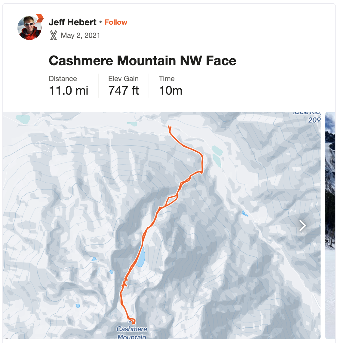
With the forecast lining up for a single day objective, Kelsey and I decided to head out to the Leavenworth area and add a new peak to our repertoire. We drove her van to the road intersection off Icicle Creek between Johnny Creek and Ida Creek around 10:30pm on Saturday night. There was enough cloud cover that it was quite dark and we couldn’t see much, but it was clear there was no snow to be found in the valley. Significant doubt set in as we conked out for the night.

We woke up at 5:45am and it was already light enough to see that there was no snow for a long ways up the mountain. The recent heat wave had significantly impacted the snowpack. We set our expectations low and donned our trail runners, planning to walk for a good ways starting at 6:30am. Thankfully, near the switchback of the forest road, a nicely-signed trail to Lake Victoria began and we followed it all the way up to near the ridge line at 3,600 feet. There were a few patches of snow to this point, but it was generally dry.

At the ridge, we couldn’t see much snow in the Victoria Creek drainage. There was a couple hundred foot section of dense slide alder that we waded through to get toward the creek, then a moderately tricky stream crossing before we got to the other side and decided to switch to skis about 2 hours from the car. We weren’t sure the snow would be continuous from here and our expectations remained low. On the more North-facing aspect, the snow was in better shape and we were able to skin up to 4,500 feet where a nice-looking gully presented itself.

We thought the summer trail followed Victoria Creek more closely, but decided this gully was more likely to have continuous snow. We skinned nearly all of it and booted the last part with icy snow. From there, we could skin again up and over a shoulder down toward Victoria Creek, eventually getting to Lake Victoria about 4 hours from the car. What a stunning spot! A bit like Colchuck Lake, but with an unfamiliar cirque of granite and no signs of civilization. Our straight-on view of the Victoria’s Secret Couloir made it look quite steep and the wet slide debris from the recent heat wave made it look like skiing it would be quite challenging.


Nevertheless, we headed across the lake to see what it looked like up close. We found the slopes to be lower angle than expected and a clear area on the climber’s right of the gully to be easy skinning. In the hot sun, we switchbacked our way up, eventually transitioning to boots and crampons to climb the gully. It got pretty steep and icy near the top, but was never too much for a single whippet.

Above the couloir, the snow was firm enough that we just stayed in boots and crampons up to a nice rest spot below the NW Face about 6 hours from the car. We had less than 1,000 feet to go at this point and could see an old boot track headed up the face. We left skis at the base of the face and headed up, traversing in from the climber’s right and then going pretty directly up to the summit block. We made it to the top in 7 hours from the car, so 1:30pm. The views of the Enchantments and Stuart Range were phenomenal. Having climbed many of the peaks and lines visible, it was really cool to see them lined up like that.

A quick downclimb closer to the North ridge brought us back to our skis. We clicked in and scraped our way down the first 500 feet or so before things warmed up and were much more fun. The couloir had seemed quite intimidating on the way up, but it wasn’t too bad to side-slip the top and then, as soon as we were through the constriction, we had the best skiing of the day on the corn below.

After a quick skate across the lake, we tried to match our up track, heading over the shoulder into our ascent drainage and then down more directly to the stream crossing. It all went smoothly and included some pretty fun turns, only getting wet and heavy down near the creek. We transitioned here 9 hours from the car and made quick work of the descent, reaching the car about 1 hour and 20 minutes later for a bit over 10 hours on the day.

Hitting this a bit earlier in the season would be recommended, but the effort to get to the snow was actually not as bad as we had expected it to be. On days when you don’t have high expectations, accomplishing anything feels pretty good. We were pretty psyched to have tagged this summit and skied this route. The subsequent burgers and beers in Leavenworth and drive home during the daylight hours added to a glorious feeling that summer is near.

In Climbing, Skiing
Comment
← Newer Posts Older Posts →
No results found

Recent Trip Reports

Featured
IMG_4236 (3).jpeg
August 6, 2026
Inspiration Traverse - Eldorado, Austera, Dorado Needle
August 6, 2026
Read more →
August 6, 2026
IMG_3486.jpeg
May 2, 2026
Boulder Glacier on Mount Baker
May 2, 2026
Read more →
May 2, 2026
IMG_1725.jpeg
August 22, 2025
West McMillan Spire Car to Car
August 22, 2025
Read more →
August 22, 2025
IMG_1244.jpeg
July 23, 2025
Via Ferrata Ferrari at Ra Bujela
July 23, 2025
Read more →
July 23, 2025
IMG_1208.jpeg
July 22, 2025
Dolomiti Vertfest
July 22, 2025
Read more →
July 22, 2025
IMG_1047.jpeg
July 19, 2025
Via Ferrata Tomaselli to Punta Fanes
July 19, 2025
Read more →
July 19, 2025
IMG_1014.jpeg
July 18, 2025
Via Ferrata Bianchi to Cristallo Mezzo
July 18, 2025
Read more →
July 18, 2025
IMG_5941.jpeg
July 15, 2025
Lake Sorapis & Via Ferrata Alfonso Vandelli
July 15, 2025
Read more →
July 15, 2025
IMG_0740 (1).jpeg
July 14, 2025
Ra Gusela and Averau Vie Ferrate
July 14, 2025
Read more →
July 14, 2025
IMG_0715.jpeg
July 11, 2025
Sci Club 18 Via Ferrata
July 11, 2025
Read more →
July 11, 2025
IMG_0634 (1).jpeg
July 10, 2025
Punta Anna and Tofana di Mezzo Via Ferrata
July 10, 2025
Read more →
July 10, 2025
IMG_0544.jpeg
July 9, 2025
Via Ferrata Michielli Strobel
July 9, 2025
Read more →
July 9, 2025
IMG_0309.jpeg
July 3, 2025
Tridentina al Pisciadù Via Ferrata
July 3, 2025
Read more →
July 3, 2025
IMG_0252.jpeg
June 30, 2025
Sellaronda
June 30, 2025
Read more →
June 30, 2025
IMG_0210.jpeg
June 28, 2025
Sass Rigais Via Ferrata
June 28, 2025
Read more →
June 28, 2025
IMG_9843.jpeg
June 19, 2025
Giro d'Langhe
June 19, 2025
Read more →
June 19, 2025
IMG_9781.jpeg
June 17, 2025
Aiguilles Marbrées Traverse
June 17, 2025
Read more →
June 17, 2025
IMG_9534.jpeg
June 9, 2025
Midi-Plan Traverse
June 9, 2025
Read more →
June 9, 2025
IMG_9162.jpg
May 31, 2025
Mallory-Porter on Aiguille du Midi
May 31, 2025
Read more →
May 31, 2025
ventoux.jpg
May 18, 2025
Mont Ventoux
May 18, 2025
Read more →
May 18, 2025
IMG_6830.jpeg
September 21, 2024
South Face on Aiguille du Moine
September 21, 2024
Read more →
September 21, 2024
IMG_6771.jpeg
September 19, 2024
Barbaresco to Barolo
September 19, 2024
Read more →
September 19, 2024
IMG_3321.jpeg
September 15, 2024
Cosmiques Arete on Aiguille du Midi
September 15, 2024
Read more →
September 15, 2024
IMG_5955.jpeg
July 27, 2024
Rainier Vertfest
July 27, 2024
Read more →
July 27, 2024
IMG_5609.jpeg
July 13, 2024
Mary Green Glacier on Bonanza Peak
July 13, 2024
Read more →
July 13, 2024
IMG_4891.jpeg
April 13, 2024
Chair Peak Circumnav CCW
April 13, 2024
Read more →
April 13, 2024
IMG_8600.jpeg
December 14, 2023
Mount Aspiring NW Ridge
December 14, 2023
Read more →
December 14, 2023
IMG_2329.jpeg
July 16, 2023
West Ridge on Mount Thomson
July 16, 2023
Read more →
July 16, 2023
IMG_1974.jpeg
May 28, 2023
South Ridge on Mount Jefferson
May 28, 2023
Read more →
May 28, 2023
IMG_1736.jpeg
May 13, 2023
Little Tahoma via Paradise
May 13, 2023
Read more →
May 13, 2023

© 2020 Jeffrey J. Hebert